Sunday, January 21, 2007

1830 Population and School Districts

By 1830
The population of the Town of Ripley had grown to six hundred forty-five (645) individuals. There were three hundred thirty-five (335) males and three hundred ten (310) females. About half of the inhabitants of the town were age
0 - 15 years. Because of the number of young people, by the mid 1830's there were six school districts in the town.
An account of how the District 1 School came to be built still exists:

"To the Selectmen of Ripley

We the subscribers in the inhabitants of said town belonging to District No. 1 request you to establish a place to erect a school house in said District 1 near the center of the same.

Moses Bane
Jonathan Dickey
Francis Frost
Samuel Emery
Samuel Emery Jr.
Joseph Butler
Edward Leavitt Jr.

Ripley June the 18th 1823
This May entify that we have attended to the Location of the place for a schoolhouse in District No. 1 acording to a Request from Samuel Emery and others and we have Asertained the Distance as Near as we can by the plan and find the most convenient and central place for the said house at the corner of the old county and South Roads Near the House of Samuel Emery Jr. in said District to the Superentending School Committee of said district.

Elisha Bane
Joseph H. Perkins Selectmen of Ripley" (sic)
{click on images to enlarge}
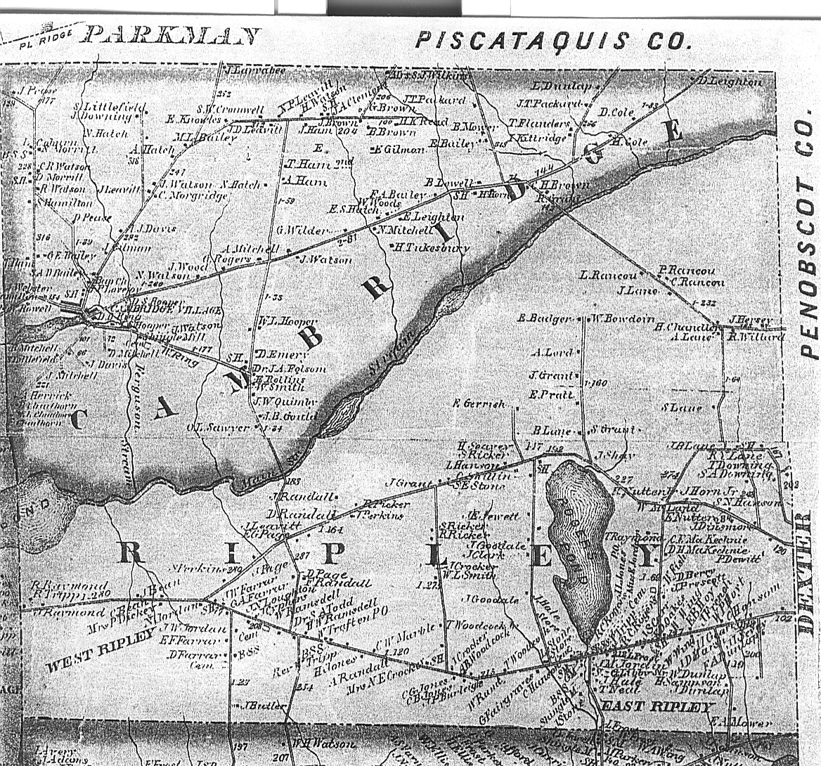
The location of this school was on Dickey Hill on the "South Road" (this is now Rte. 154). By looking at the map, you can see where it was located in relation to West Ripley Cemetery. When traveling down the hill you can still see where the "Old County Road" used to meet the "South Road". Some of the names of the families who requested the school can be seen on the map. This school was known as the "Hillside School". The schoolhouse was later moved to the Laughton Farm on the "Laughton Road" now the Chadbourne Road.

Monday, January 15, 2007

Census of 1820, Ripley, Maine


Ripley Census of 1820

In comparing the 1810 and 1820 census reports, we find that the population of Ripley has more than doubled from 117 to 325 in ten years. Of the original 24 settling families, 12 remain. These are: Cyphers, Davenport, Dickey, Emery, Fish, Hale, Leavitt, Libby, McFadden, Page, Randall and Sturgis.

Maine has separated from Massachusetts to become a state.

The Headings of the form are as follows:

Names of Heads of Families/ Free White Males/ Free White Females/ Foreigners not naturalized/ Numbers of Persons Engaged in Agriculture/ Numbers of Persons Engaged in Commerce


Under Free White Males the distinctions are as follows:
Under 10/ 10 and under 16/ between 16 and 18/ 16 and under 26/ 26 and under 45/ 45 and over

Under Free White Females the distinctions are as follows:
Under 10/ 10 to 16/ 16 and under 26/ 26 and under 45/ 45 and over


The 50 Heads of household in Ripley, Somerset County, Maine in 1820 are: (alphabetically)

Moses Bane
Joseph Butler
Metiah Cobb
Nathan Clark
Elijah Clark
*David Cyphers
Andras Cobb
William Dunlop
*John Deavanport
*Jonathan Dickey
Thomas Downing
Atkins Elice (Ellis)
John Emery
*Samuel Emery
*Browning Fish
Francis Frost
William Hoit (Hoyt)
Thomas Horn
*Jacob Heald Esq. (Hale)
Elijah Hambleton (Hamilton)
Earron Harris (Aaron)
Forrist Hatch (Forest)
Jonathan Hambleton (Hamilton)
Jessie Hambleton (Hamilton)
Jonathan Jones
Fosse Hambleton (Foss Hamilton)
John Jones
Zachens? Judkins
Benjamin Kimble (Kimball)
Ephraim Knowles
Abigail Jackman
Charles Leighton
Samuel Leavitt
*Edward Leavitt
Abraham Littlefield
Moses Leighton
*Winston Libby
Bela P. Morse
*James McFadden
William Hopkins
Edward Perry
*Josiah Page
Ephraim Pettengill
*David Randall (Daniel)
John Roggers (Rogers)
James Roggers (Rogers)
*David Sturgis
Samuel Sparr
Polly Thurstin (Thurston)
John Todd
Joseph Tyler
George Wild
Jonathan Watson
Ephraim Watson
Richard C. Roggers (Rogers)

* designates H. of Household from 1810 Ripley census.


Welcome to the Ripley, Maine Blog

This blog contains historical Information and images from private collections featuring:
Ripley, Somerset County, Maine
from 1800 to the present.

This is a view of Ripley Village looking North from Water Street. Left to right are: Dot Hanson's General Store, Nora Hamilton's Dry Goods Store (which later also included the Crocker Free Library), horse stables, and Edgar Ramsdell's General Store. Two of the children in the foreground are Willie and Edgar Cross.

Ripley Census of 1810


Ripley Census of 1810

Still a part of the State of Massachusetts….Ripley was known as Township Number 5 in the Fifth Range in the District of Maine.

This list comprises the first settlers of this township. Many of these men were taking up land grants given to them for service in the Revolutionary War. Some of them were sons or relatives of veterans of The War of Independence and were settling on grants purchased from others. There are 24 Heads of Household listed. The total population was 117 persons.

The Headings of the form are as follows:

Names of Heads of Families Free White Males Free White Females All Other Free Persons Slaves
Under "Free White Males" and Free WhiteFemales" the distinctions are as follows:Under 10/ 10 thru 15/ 16 thru 25/ 26 thru 44/ 45 and over
Names included in this census* in order recorded and as spelled are:

Thomas Horn
Browning Fish
David Sturges
John H. Tucker
Stephen Tucker
Silas Emery
Joseph Gray
Isiah Brooks
John Gray
Nathan Burton
John Davinport
David Cyphers
David Maloon
Samuel Emery
Josiah Page
Daniel Randal
Edward Levitt
Abijah Sturtrvant
Jonathan Dickey
Nahemiah McDaniel
James McFadden
Wintworth Libby
Jacob Hale
James Field
*Census conducted by Jacob Hale

For example:
Jacob Hale’s household consisted of himself (he was between the ages of 26 – 34), 2 males under 10 years of age, 1 female under 10, and one female 16 – 25.

The first white child born in T5 R5 was Jaal Field. In 1810 there was only one female listed in Jonnas Field's household... she was listed as 10 thru 15. If Jaal survived early childhood, this could be her, and would put her birth c. 1799 - 1800.

Map of Ripley c. 1860


Ripley, Maine was settled at the turn of the 18th century. Some of the earliest settlers arrived in the late 1790’s. Township 5 Range 5 was an unorganized township North of the Waldo Patent. It was incorporated as a town on December 11, 1816. Maine became a state in 1820. The town was named for Eleazer Wheelock Ripley who was an officer in the War of 1812. On Feb 8, 1834, the northernmost part of Ripley was set aside and incorporated as the town of Cambridge. The East Branch of the Sebasticook River or “Maine Stream” forms the boundary between the two towns.
Ripley is , therefore, the Southern half of an original 6 mile square township.

**If you click on the picture it will give you a larger view.

Winter 1912

This is a picture of Alvin and Daniel Randall. It is taken at the Randall farm in Ripley, Maine c. 1912. Alvin was born in 1894, his brother Dan in 1907. They were the sons of Mellen Alvin Randall and Estelle Crockett Randall. This view was taken looking north towards Cambridge. Note how clear the land was. It is all wooded now. Alvin lived most of his life in Ripley. He died in 1979.

Sunday, January 14, 2007

1882 News Article

This article from the Lewiston Evening Journal is from 1882. The article gives you a brief snapshot of what life was like in Ripley, in the winter.

Census of Ripley,  Maine c. 1910 From:   " The East Somerset County Register"    Compiled and Published by Chatto & Tu...